Urban transition area
León, located about 93 km northwest of Managua and known for its colonial heritage, is Nicaragua’s second-largest city with 180,000 inhabitants. It is known as both a lively student city and as one of the ancient intellectual centers of the country. The city structure is typically Latin American: One main square (Parque Central) together with a cathedral, a town hall, and several administration buildings representing the city core and the touristic center. León is fortunate to possess two rivers—Río Chiquito and Río Pochote—that have the potential to become major recreational areas for Leon’s inhabitants. However, the current state of these water bodies is characterized by high levels of contamination due to the disposal of domestic waste and waste water as well as industrial effluents stemming from the nearby tanneries and slaughterhouses. While the Chiquito River traverses the city from east to west through the southern parts of the center that are densely populated, the Pochote River originates at the northern city boundary and has recently become part of the urbanized area due to rapid urban expansion throughout the last decades.
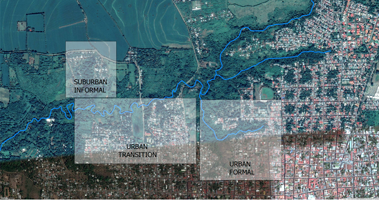
The project team is focusing on the Pochote River since it offers more opportunities to test numerous Nature-Based Solutions because of the different degrees of urbanization along the river. In addition, very different socio-economic characteristics and social practices can be found in these areas.
Overview of the Pochote River and The Northern Part of León
 ©
SEE-URBAN-WATER
©
SEE-URBAN-WATER
The Pochote River flows 6 km along the northern border of the city of León until it merges with the Chiquito River a few kilometres west of the cities limits. Its origin is comprised of three channels, each channel approximately 1 km long. Despite being located in a highly urbanized area, the river’s topography limits its accessibility. On the mid-course, a single stream channel forms meanders and floodplains. These hydro-morphological characteristics have not only developed different ecological conditions around the river but have also influenced different settlement patterns. The most important water-related issues stem from the inefficient operation of local wastewater treatments plants and sewage systems, direct discharge of untreated wastewater from households along the shore, hydraulic stress due to high amounts of surface runoff from sealed surfaces, and garbage burning and disposal. Three zones have been identified in our research project as potential study areas (see interactive map).